The Elgin Hiking Trail Guidebook is out of print effective August 2015
List of access points to Elgin Trail (south to north)
William St, Port Stanley, ON Long: -81.21615 Lat: 42.65953 Elev: 174m or 571 feet
Carlow Rd, Port Stanley, ON Long: -81.22182 Lat: 42.67398 Elev: 183m or 600 feet
Thomas Rd, Port Stanley, ON Long: -81.22506 Lat: 42.68030 Elev: 198m or 650 feet
Union Rd, Port Stanley, ON Long: -81.22132 Lat: 42.69091 Elev: 195m or 640 feet
Sparta Line, Union, ON Long: -81.20756 Lat: 42.70490 Elev: 199m or 653 feet
Mellor Rd opposite Fulton Bridge Line, Southwold, ON Long: -81.21162 Lat: 42.71919 Elev: 213m or 699 feet
John Wise Line, St. Thomas, ON Long: -81.21161 Lat: 42.73604 Elev: 205m or 673 feet
Southdale Line, St. Thomas, ON Long: -81.20566 Lat: 42.74933 Elev: 214m or 702 feet
Sunset Café – 184 Sunset Drive, St. Thomas, ON Long: -81.19765 Lat: 42.76234 Elev: 228m or 748 feet
Fingal Line at Sunset Dr, St. Thomas, ON Long: -81.21266 Lat: 42.77799 Elev: 213m or 699 feet
Lyle Rd, St. Thomas, ON Long: -81.26575 Lat: 42.78613 Elev: 227m or 745 feet
Red Barn at Paynes Mills, St. Thomas, ON Long: -81.28546 Lat: 42.78874 Elev: 217m or 712 feet
Southdel Dr, Southwold, ON Long: -81.34052 Lat: 42.81429 Elev: 224m or 735 feet
Trail Reroutes
Map 2 Highway 401 Overpass to McGoogan Bush
The access between fields on Mill Road no longer exists. Fence row has been removed. Therefore Map 2 – Highway 401 Overpass to McGoogan Bush should now read. After crossing Highway 401 on Mill Rd keep going till you reach Fourth Line. Turn left on Fourth Line and continue to Parsons Rd. Note: This now makes a continuous stretch of approximately 10 km of road hiking.

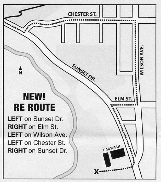
Map 8 Trestle Bridge to Car Wash Junction
Page 21 first paragraph reads “Walk south along Highway 4 which is Sunset Drive in St. Thomas, cross a second bridge.” then follow instructions below
“Continue along Sunset Drive to Chester Street. Due to busy road the trail has been closed at Hwy 4 which is Sunset Drive in St Thomas at Chester Street. The reroute is turn left up Chester Street to Wilson Avenue, turn right on Wilson Avenue to traffic lights at Elm Street. Turn right on Elm Street to Hwy 4 (Sunset Drive) cross at lights and turn left towards Port Stanley. At Sunset Cafe turn in and head to south end of car wash. Follow trail markings onto trail and continue with Map 9.”
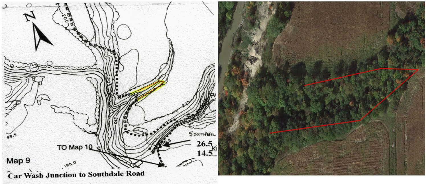
Map 9 – Car Wash Junction to Southdale Road
Page 22 paragraph 3 reads
“Their work includes two bridges, a 14′ bridge halfway down and a 30 foot bridge across the gully. Assend the southside of the valley on the switchback trail to the top of the hill.”
The 30 foot military bridge is on a steep angle due to erosion on the south side and is unsafe. The bridge is now CLOSED.
The guide should now read
Their work includes a 14 foot bridge partway down, cross this bridge and proceed following blazes up the hill. The new route will take you around the top of the ravine and cross at the end of ravine and back along top.